Posts

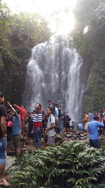
Kempty falls, Mussoorie

Image
Kempty Falls  is a waterfall in Ram Gaon and at the south of Kempty, in the Tehri Garhwal  District of Uttarakhand  , India  . It is 13 kilometres (8 mi) from Mussoorie   on the Chakrata Road, and 45 kilometres (28 mi) from Dehradun . It is nearly 1364 meters above sea level, at 78°-02’East longitude and 30° -29’North latitude. The Kempty Falls, and the area around is surrounded by high mountain ranges at an altitude of 4500 feet. There is an estimated tourist inflow to the Falls of over 10 lakh (one million).

Brahmaputra, assam

Image
The Brahmaputra River is one of the largest rivers in the world and is also one of the major rivers of Asia.  It is a transboundary river. Brahmaputra is considered a male river, while most of the rivers in India are considered female rivers. The river is about 2900 km long. Brahmaputra is a braided river originating in southwestern Tibet where it is called Yarlung Tsangpo River. The river is considered sacred by the Hindus as many mythological tales are associated with the river.

Kakochang Waterfall

Image
Waterfalls In India Kakochang Fall is well-known eat outside picnic spot. Visitors viewing this spot could see remains of historical Numaligarh from the recreation area. The tea landscapes of Hathkhuli, Difalu, Methoni and also Behora Borchapori could also seen, while viewing fountain. Besides, the route to this fountain is the middle of rubberized farms that provide a wonderful vision. Kakochang Falls is situated about 13 kms from the Bokakhat at Jorhat Region of Assam. It can be found in between Kaziranga Nationwide Park as well as Bokakhat. It is essential eat outside spot where tourists could appreciate stunning opinions of the characteristics along with the jungles and mountains. Close by destinations consist of remains of the historical Numaligarh or Deoparbat, tea landscapes of the Methoni, Hatikhuli, Difalu as well as Behora Borchapori and this is also coffee along with rubberized farms. The closest train station is Rangia along with Furkating. The closest air-ports are-...

Roing,Arunachal pradesh

Image
Roing is the district headquarters of the Lower Dibang Valley district in Arunachal Pradesh. It is the census town and is one of the sub divisions of the Lower Dibang Valley district. The Roing circle was opened in 1951. The town is the only commercial centre to both the Upper and the Lower Dibang Valley district.

Bheloghat, Karbi Anglong, Assam

Image
The Place is very awesome and romantic. It is located in the district Karbi Anglong.